Driving Distances in Ireland: Road Distances, Journey Times & Route Planning
Planning a journey in Ireland often starts with a simple question: how far is it from one place to another? Learn how road networks, road types, tolls, and geographical features influence driving distances and journey times across Ireland.
The answer isn't always as straightforward as it might seem. The distance between two locations can be measured as a straight line across the map, along the road network, or as part of a particular driving route. These different measurements can produce quite different results.
A journey that looks short on a map may take considerably longer than expected because of the type of road, traffic, junctions, towns along the route or the terrain.
Whether you're planning a daily commute, a holiday road trip or simply trying to find out how far it is between two Irish towns, understanding the difference between distance, route and journey time can help you plan more effectively.
The Maps.ie Route Planner can calculate driving routes throughout Ireland, including distance, estimated journey time and step-by-step directions. It also allows you to add stops and choose options such as avoiding motorways and toll roads.
What Is Driving Distance?
Driving distance is the distance travelled along a road network between two locations. It is different from the straight-line distance between the same two points.
For example, imagine two towns that are 80 kilometres apart when measured directly across the map. The actual driving distance might be 100 kilometres because there isn't a road that follows a straight line between them. Roads have to follow the geography of the landscape and connect with existing towns, bridges, junctions and other roads. As a result, the route taken by a car will usually be longer than the direct geographical distance.
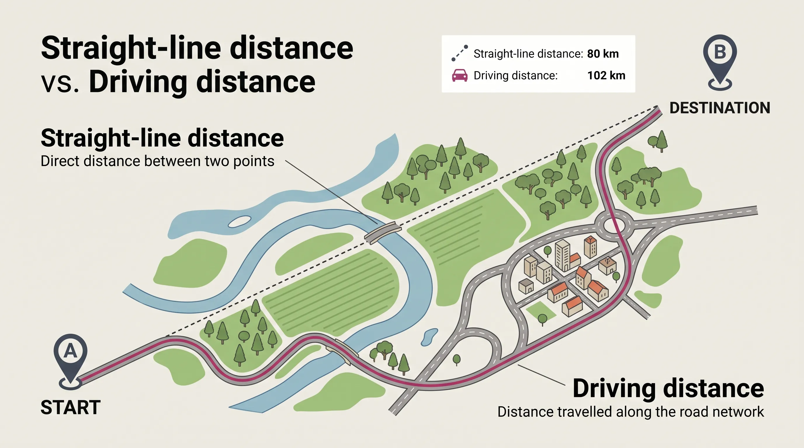
Driving Distance vs Straight-Line Distance
There are several ways of measuring the distance between two locations:
Straight-line distance
Direct distance between two points ("as the crow flies"). Ignores roads, terrain, and obstacles.
Driving distance
Follows the available vehicle road network between starting point and destination.
Walking / Cycling
Utilises footpaths, greenways, and shortcuts inaccessible to motor vehicles.
This distinction is important when using online maps. The Maps.ie Distance & Area Calculator allows you to measure direct distances between points on a map, while the Route Planner calculates a route through the road network.
Straight-line distance = how far apart two places are.
Driving distance = how far you need to travel by road.
How Are Driving Distances Calculated?
A modern route planner uses a digital representation of the road network to determine how locations can be connected. The Maps.ie Route Planner uses the GraphHopper engine for routing, supporting driving, walking, and cycling modes.
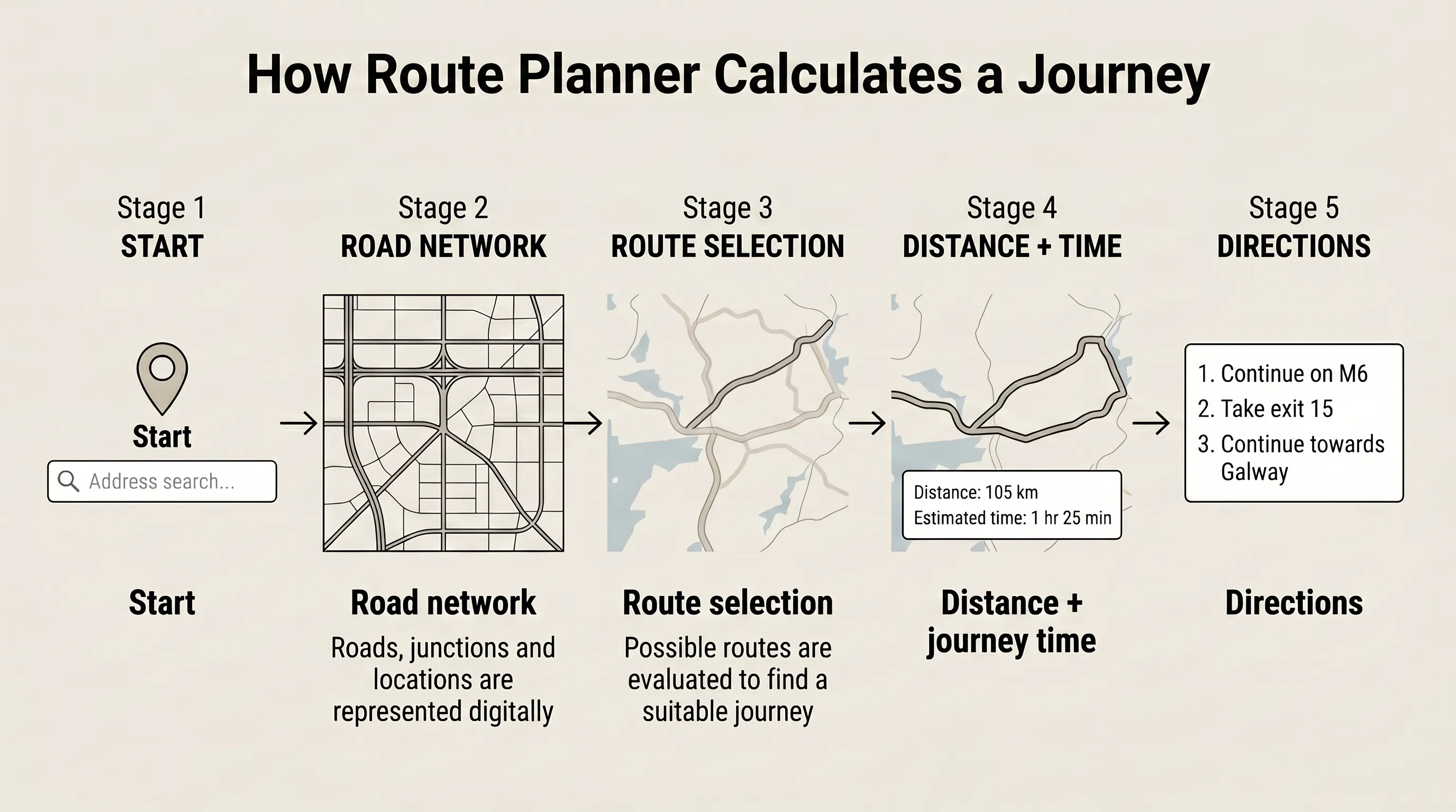
- 1 You enter your starting location.
- 2 You enter your destination.
- 3 The locations are matched to points on the digital map.
- 4 The routing system identifies roads connecting the two locations.
- 5 Different possible routes are evaluated.
- 6 A route is selected based on the available routing options.
- 7 The distance and estimated journey time are calculated.
Why the Shortest Route Isn't Always the Fastest Route
One of the most important things to understand about route planning is that the shortest route and the fastest route aren't necessarily the same.
| Option | Distance | Estimated Journey Time |
|---|---|---|
| Route A (Shorter) | 90 km | 1 hr 45 min |
| Route B (Fastest) | 105 km | 1 hr 25 min |
In the comparison above, Route B is 15 kilometres longer but gets you to your destination 20 minutes sooner because it utilizes higher-speed motorways, fewer town bottlenecks, and fewer traffic lights.
Driving Distance vs Driving Time
Journey time across Ireland is heavily influenced by:
- Road classification & speed limits
- Traffic congestion & urban bottlenecks
- Junctions, roundabouts & traffic lights
- Town and village transit zones
- Active roadworks & diversions
- Weather and visibility conditions
Understanding Ireland's Road Network
The type of road you travel on has a significant impact on both distance and speed. Ireland's road network is categorized into distinct functional classifications:
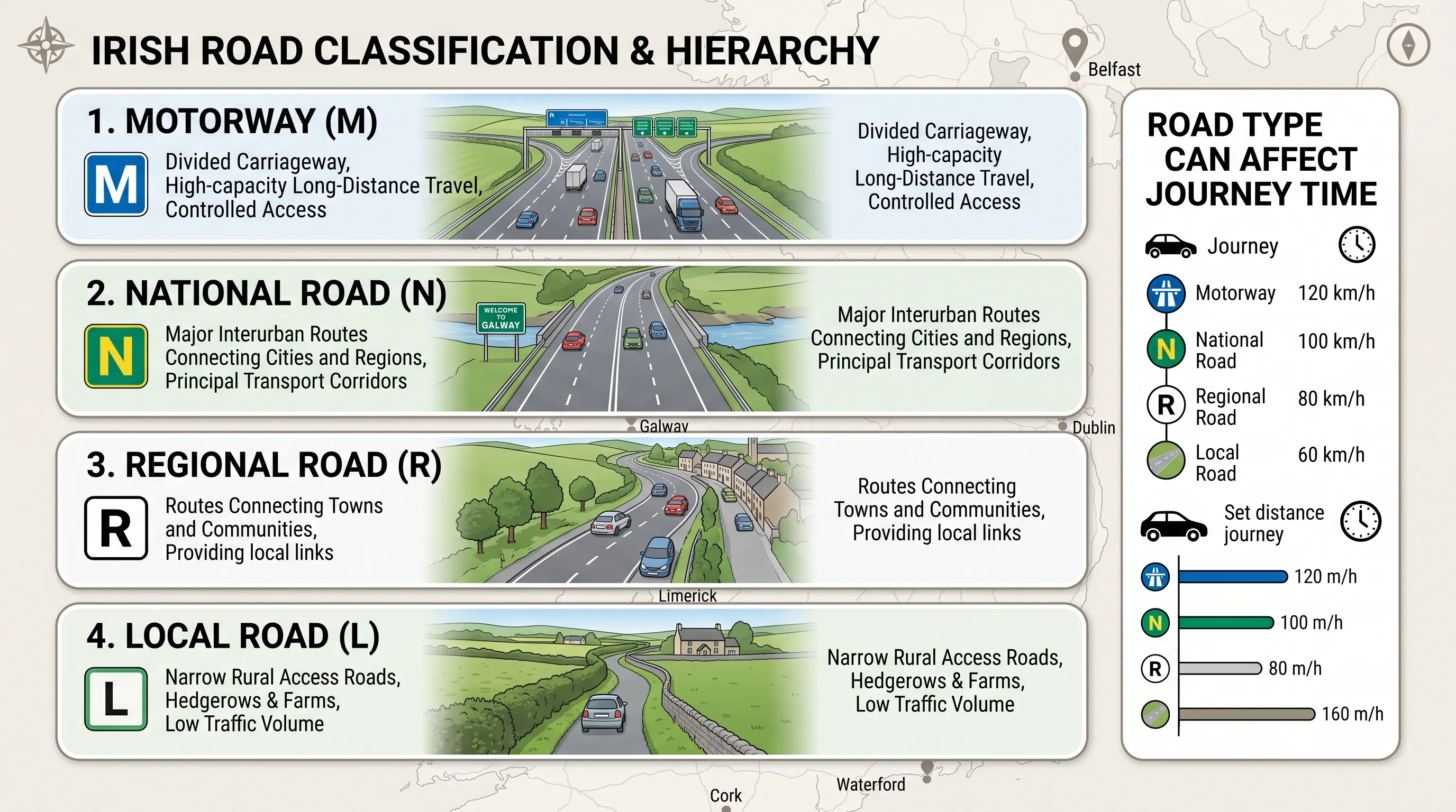
Motorways (M): High-capacity divided carriageways designed for long-distance intercity transit with controlled access and higher speed limits.
National Roads (N): Primary corridors connecting major cities and towns. Includes dual carriageways and high-grade single-carriageway routes.
Regional Roads (R): Secondary arterial routes linking local towns and rural districts, featuring more frequent junctions and lower average speeds.
Local Roads (L): Narrow access roads servicing rural farms, residences, and smaller communities, requiring cautious driving due to tight bends and obstacles.
Toll Roads in Ireland
Toll roads operate on major motorway routes across Ireland (e.g. M50 barrier-free toll, M1, M3, M4, M7/M8, M8, N6, N8, N18 Tunnel, Port Tunnel) overseen by Transport Infrastructure Ireland. Drivers can choose between taking the fastest route (which may involve toll plazas) or selecting a no-toll route in their navigation settings to minimize travel costs.
Calculate Your Route & Driving Distance
Enter starting point and destination to get exact distance, estimated driving time, turn-by-turn directions, toll settings, and motorway routing.
How Far Is It Between Ireland's Major Cities?
Ireland's principal urban centers are relatively close geographically, but exact road distances depend on your precise starting address and route configuration:
| City Route | Approximate Driving Distance |
|---|---|
| Dublin – Galway | About 200+ km |
| Dublin – Cork | About 250+ km |
| Dublin – Limerick | About 200 km |
| Galway – Limerick | About 100 km |
| Cork – Limerick | About 100 km |
| Dublin – Waterford | About 170 km |
| Galway – Cork | About 200 km |
These figures are approximate. For pinpoint door-to-door distances, input specific street addresses into the Maps.ie Route Planner.
Why Irish Driving Times Can Be Longer Than Expected
Visitors to Ireland often assume a 100-kilometre drive will take approximately one hour. In rural districts, scenic regions, or coastal routes, actual driving times can be significantly higher.
Scenic & Rural Terrain
Narrow lanes, sharp bends, steep mountain passes, coastal routes, and passing places in Connemara, Kerry, West Cork, and Donegal.
Local Traffic Obstacles
Farm machinery, cyclists, tour coaches, pedestrians, livestock, and limited overtaking opportunities on regional roads.
Planning a Multi-Stop Journey
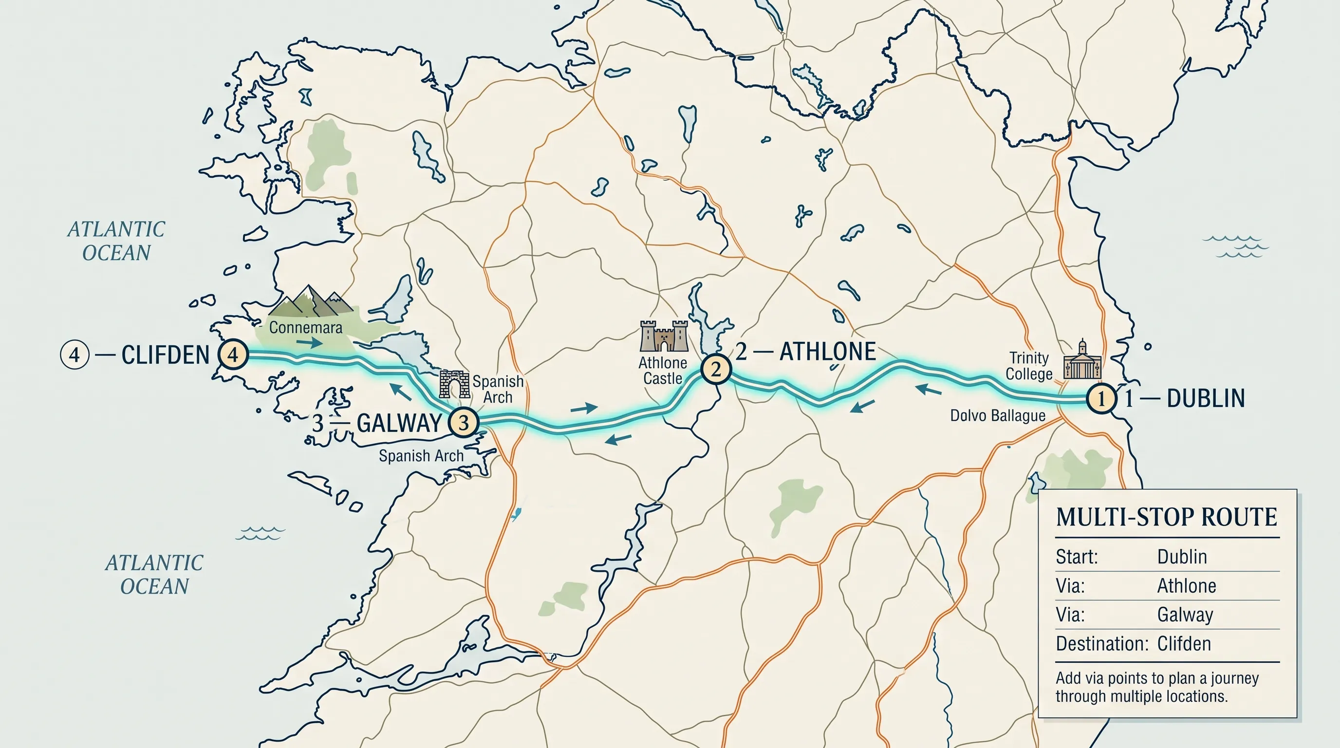
Many road trips in Ireland involve traveling through intermediate waypoints rather than direct A-to-B trips. Multi-stop route planning allows you to sequence waypoints efficiently in one complete itinerary.
Kilometres vs Miles
Ireland uses kilometres for distance signs and posted speed limits. Visitors from countries using miles can reference these conversions:
Note: 1 km ≈ 0.62 miles | 1 mile ≈ 1.61 km. The Maps.ie Route Planner allows toggling unit output between KM and Miles.
How to Plan a Long-Distance Drive in Ireland
Follow this essential 8-step checklist before departing on major intercity or rural drives:
Common Questions
Driving Distances FAQ
How do I calculate the driving distance between two places?
Use a route planner that follows the road network. Enter your starting location and destination to calculate the road distance and estimated journey time.
Is driving distance the same as straight-line distance?
No. Straight-line distance measures the direct distance between two points, while driving distance follows the available road network.
Is the shortest driving route always the fastest?
No. A longer route using motorways or higher-speed roads can sometimes take less time than a shorter route using slower roads.
Can I avoid toll roads and motorways in Ireland?
Yes. The Maps.ie Route Planner includes toggle options to avoid toll roads or customize motorway preferences when calculating driving routes.
Can I plan a route using GPS coordinates or add multiple via-stops?
Yes. You can enter precise latitude/longitude pairs as route inputs and add intermediate via stops to sequence multi-stop itineraries.