GPS Guide: How GPS Works, Coordinates, Devices & Navigation
GPS is now part of everyday life. Learn how satellite positioning determines your location, how to read latitude and longitude, and how to use digital mapping tools effectively.
Need to Find Your GPS Coordinates?
Search any address, click on the map, or detect your current position to instantly extract precise latitude, longitude, and elevation data.
1. What Is GPS?
GPS stands for Global Positioning System. It is a satellite-based positioning, navigation and timing system operated by the United States.
The GPS system uses satellites orbiting Earth, a network of ground-based control facilities and receivers used by people and devices around the world. GPS was originally developed for military purposes but has become an essential utility for smartphones, cars, watches, hiking devices, marine equipment, and digital mapping apps.
Position
Identifies exactly where you are on Earth.
Navigation
Shows where you are going and how to get there.
Timing
Provides atomic-clock precise timing signals.
What is GNSS?
GNSS stands for Global Navigation Satellite System. Although people often use "GPS" as a generic term, GPS is actually one member of a wider group of satellite constellations across the globe:
| System | Operator |
|---|---|
| GPS | United States |
| Galileo | European Union |
| GLONASS | Russia |
| BeiDou | China |
2. How Does GPS Work?
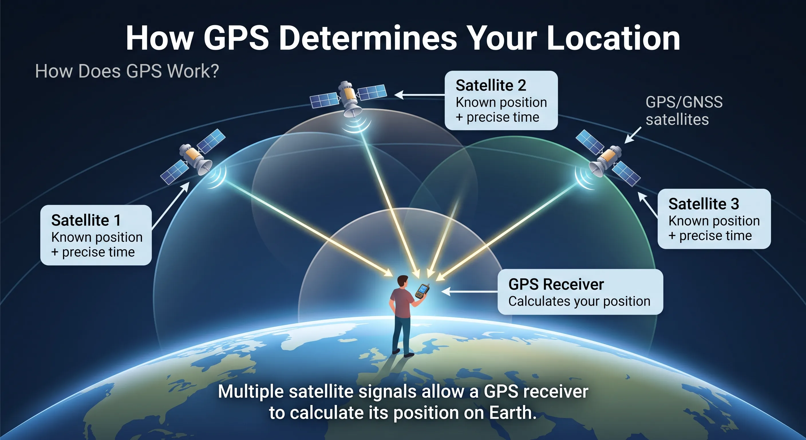
GPS works by using signals transmitted from satellites orbiting Earth at an altitude of approximately 20,200 kilometres. Each satellite continuously broadcasts its location and a precise timestamp. Your GPS receiver compares the signal transmit time with arrival time to determine distance.
Understanding Trilateration
A single satellite indicates that you are located somewhere on a sphere surrounding that satellite. Adding a second satellite narrows your position down to an intersecting circle. A third satellite narrows it to two specific points in space—one of which is on Earth. A fourth satellite provides 3D positioning (latitude, longitude, and elevation) while correcting clock discrepancies in the receiver.
3. How Accurate Is GPS?
A smartphone or consumer GPS device can typically determine position to within 3 to 5 metres under clear sky conditions. However, positioning accuracy varies based on environmental factors.
Factors Affecting Signal Accuracy
- Tall urban buildings ("urban canyons")
- Dense tree canopy and thick forests
- Steep mountain walls and valleys
- Indoor structural shielding
- Atmospheric and ionospheric delays
- Reflected signal interference (multipath)
Note: Consumer GPS is suitable for general navigation and hiking, but professional land surveying or property boundaries require specialized differential GNSS equipment.
4. What Are GPS Coordinates?
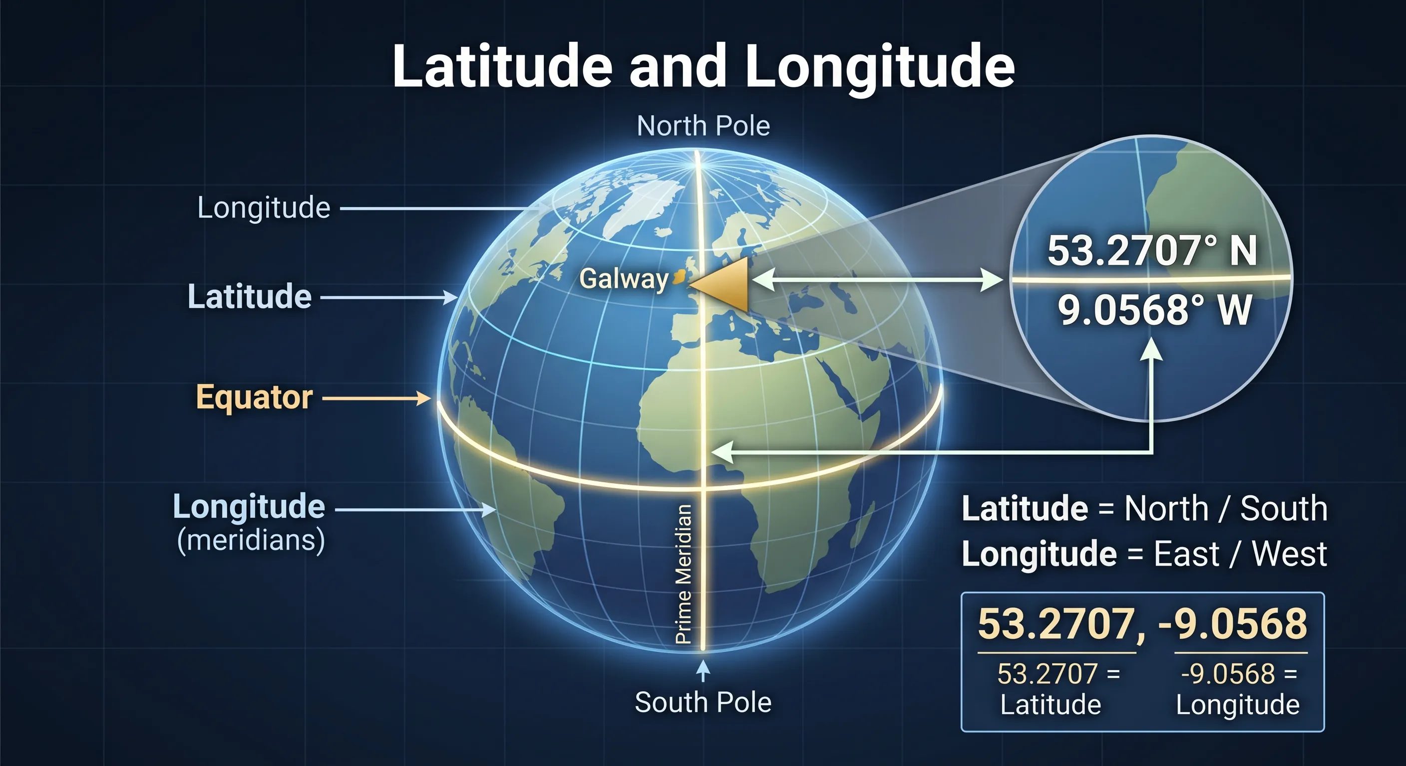
GPS coordinates are numerical values used to identify any geographical point on Earth. Coordinates are expressed as a pair of numbers: Latitude and Longitude.
Latitude (North / South)
Measures distance relative to the Equator (0°). Reaches 90° N at the North Pole and 90° S at the South Pole. Positive values represent the Northern Hemisphere.
Longitude (East / West)
Measures distance relative to the Prime Meridian (0°) in Greenwich. Extends up to 180° East or West. Negative decimal values represent Western longitudes.
5. GPS Coordinate Formats
The same location can be written in three primary coordinate notations. Understanding format differences ensures accuracy when sharing data or entering coordinates into GPS receivers.
Decimal Degrees (DD)
Most Common Online53.2707, -9.0568
Simplest format for web mapping, spreadsheets, and digital software. Positive/negative signs indicate hemisphere direction.
Degrees, Minutes & Seconds (DMS)
53°16'14.5"N 9°03'24.5"W
Traditional navigational format dividing degrees into 60 minutes and minutes into 60 seconds.
Degrees & Decimal Minutes (DDM)
53°16.242'N 9°03.408'W
Standard format widely utilized in handheld hiking devices, marine charts, and aviation.
6. How to Find & Use GPS Coordinates
Finding precise coordinates allows you to pinpoint locations without street addresses, such as trailheads, emergency assembly points, or remote field locations.
-
1
Use the Maps.ie Finder
Open the Maps.ie GPS Coordinates tool, search an address, or drag the map marker to immediately retrieve latitude, longitude, and elevation.
-
2
Always put Latitude First
When entering coordinates manually into software, ensure latitude is entered first and longitude second. Reversing them (
-9.0568, 53.2707) will target an entirely different location on Earth.
7. Types of GPS Devices & Features
Choosing the right positioning receiver depends on your activity context and environmental conditions.
Smartphones
Convenient for everyday driving and urban walking. Limited by battery life and fragile screens in harsh weather.
Handheld Outdoor GPS
Rugged, waterproof units with physical buttons, multi-day battery power, and offline topographic mapping.
GPS Smartwatches
Ideal for running, cycling, and fitness tracking. Tracks distance, speed, heart rate, and route elevation profiles.
Marine & Automotive
Fixed multi-constellation units built for vehicular dashboards or boat helm stations displaying depth charts and road networks.
8. GPS for Hiking: Waypoints, Tracks & Elevation
GPS navigation is invaluable for outdoor safety. It allows hikers to track routes, measure ascent profiles, and pinpoint key landmarks in low visibility.
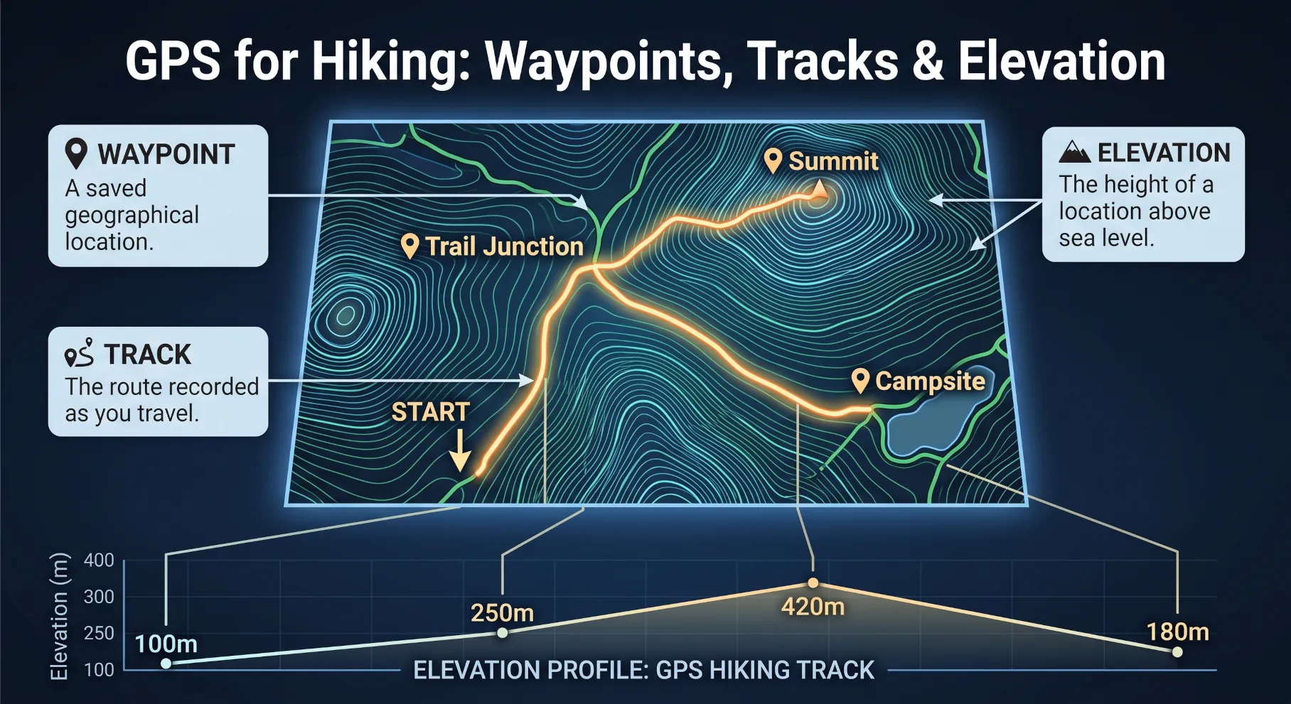
Waypoints: Saved geographic coordinates representing important points like summits, water sources, trail junctions, or campsite locations.
Tracks: Continuous breadcrumb trails recorded automatically by your GPS device as you move across terrain.
Elevation: Altimeter profile showing total vertical ascent and descent, critical for gauging trail difficulty.
9. GPS, Coordinates & Maps.ie Tools
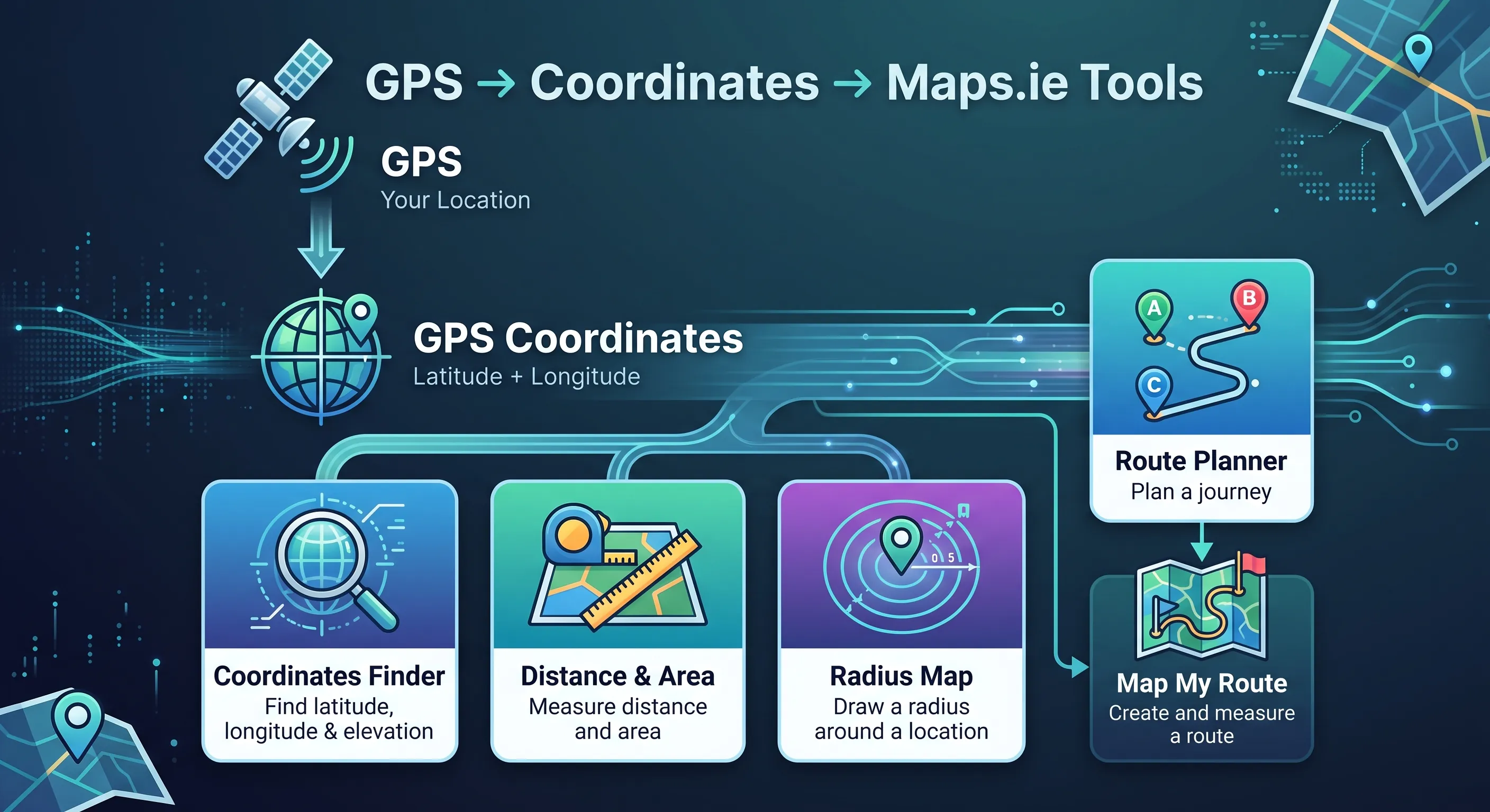
Once GPS locates your position and expresses it in coordinates, you can leverage Maps.ie mapping tools to plan journeys, measure distances, or build custom maps.
Distance & Area Calculator
Measure land plots, boundaries, and direct point-to-point distances.
Radius Map Tool
Draw circular travel or service distance zones around any pin.
Interactive Route Planner
Calculate driving, walking, and cycling directions with multi-stops.
Map My Route
Plot outdoor running or hiking paths with elevation graphs.
Common Questions
GPS Frequently Asked Questions
What does GPS stand for?
GPS stands for Global Positioning System. It is a satellite-based positioning, navigation and timing system operated by the United States.
How does GPS calculate my position?
GPS receivers calculate position using signals received from multiple satellites. By determining the exact distance to at least four satellites, the receiver uses trilateration to pinpoint latitude, longitude, and altitude.
Can GPS work without a mobile phone signal?
Yes. Satellite positioning is entirely independent of cellular networks. However, smartphone apps require downloaded offline maps to display your location background image when cellular data is unavailable.
What is the difference between GPS and GNSS?
GPS is one specific constellation managed by the United States. GNSS (Global Navigation Satellite System) is the overall category that includes GPS alongside Europe's Galileo, Russia's GLONASS, and China's BeiDou.